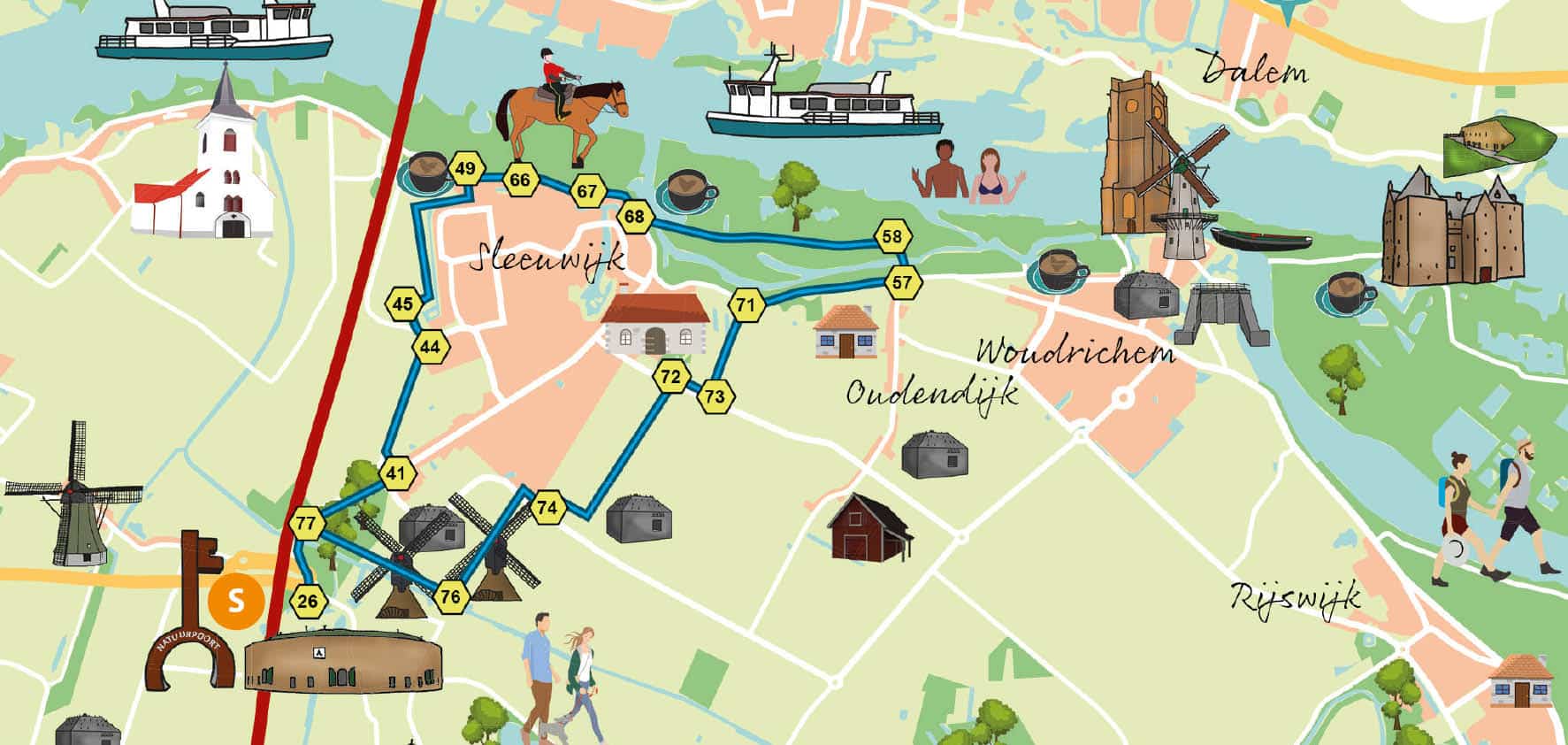
We leave from the parking lot at Fort Altena. We decide to hike first and then have lunch at the brasserie. The walk starts with a sneaky hidden forest path (just before the bridge to the fort on the left) towards node 26. We cross (carefully!) the road and walk left down the bike path to 77, where we let the traffic rush off us towards 76.
Along the way we come across several casemates, one of which, with a steel dome, serves as a birding station. Continuing along the water we see two magnificent water mills (when the sails turn, they are well worth a visit!). At 76 we keep left on the cart track between the fields (the edges are planted in a bird-friendly way). Arriving at the road we cross straight over and turn right onto the loamy path, closely followed by the extremely curious sheep. We stop for a moment at the casemat to read the beautiful poem.
We walk on to 74 where we turn left (through the gate) and right again at the end. On our right a little further on we see the care farm's vegetable garden and a long row of hop piles (these hops are the main ingredient of Altena Beer). At the end of the path we turn left over the small bridge and walk between the trees in a straight line towards 72. Here we cross the road and turn left into the driveway and before the fence turn right, across the grass towards 73. This sounds complicated, but it's not too bad! We turn left and walk in a straight line to 71, where we climb left up the Merwededijk. At the top we keep to the right, taking a break on the windy asphalt dike to 57. In the distance we see the tower of the fortified town of Woudrichem and to our left the activity on the river.
At 57 we descend outside the dike, into the floodplain. Again a beautiful piece of nature reserve managed by Brabants Landschap. Swallows nest in the banks and the kingfisher is also a regular guest in this nature reserve. At 58 we keep right and walk, largely along the river, towards 68 (we could not find the pole, but it must be near Brasserie Boven de rivieren). Now we have to pay attention: turn right towards the village edge, turn right again (along the dike below) and at 67 turn right for part II of the floodplain. We walk between the cows, along the river. The landscape of yesteryear on our left, ultramodern barges on the river to the right, and in the distance right in front of us the arches of the Merwede Bridge.
We keep walking along the river until we reach the never-used, accidentally placed bridge piers. There we turn left toward 66. We leave the thicket behind to turn right on the dike towards 49. Here we turn left down the dike, onto Notenlaan, and then take the 2nd right (footpath between the houses) opposite Herman de Ruij- terweg. We follow this Giethoorn-like path to 45 and turn left towards 44. This is a tricky part and we take care when crossing. On the bike path we turn right towards 41, right again towards 77 and straight on towards 26. We are back where the trip began. We find a nice spot on the terrace at Fort Altena. Cheers!
Tip! Tours are regularly provided, regular tours and tours with the Laundress of Fort Altena. Check the calendar to see when these tours are.
Overview of all our routes in the Nieuwe Hollandse Waterlinie

Activity: hiking