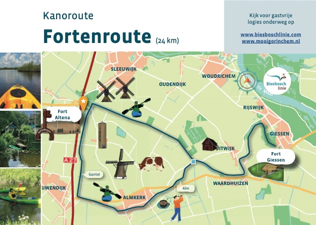
The circuit around Almkerk is 14 km sail, but if you really don't want to miss anything, take the route to Giessen as well and cruise from fort to fort!
The route on the Alm passes remarkable heritage and lies between Fort Altena and Fort Giessen. At the triangle of waters, near the picturesque village of Uitwijk, you pass an aqueduct. This, now a municipal monument, was built in the 1960s to separate two catchment areas. A boat crossing was installed here, as was also done north of Fort Altena near Uppel. A boat transfer was used to hoist a maintenance boat over the weir. You don't need something like this for your canoe, but it is special to encounter a rare landscape feature like this no less than twice on this trip.
Back to the little aqueduct: at this junction it's all about which way you want to go. You lift your canoe into the right channel and continue your route. The route largely follows the Alm River, which branches off from the Waal in Roman times.
Roman artifacts were recovered on the stream ridge. From the Middle Ages on, the Alm was a tributary of the Meuse. Today, the Alm is no longer in direct connection with the major rivers.
You start at Fort Altena and can sail right through the polder to near Fort Giessen. Both forts are part of the New Dutch Waterline; an 85-kilometer line with 45 forts, 6 fortresses and 2 castles.
The New Dutch Waterline is the largest national monument in the Netherlands which also includes Fort Steurgat, Fort Bakkerskil, Slot Loevestein, Fort Vuren and the fortified towns of Woudrichem and Gorinchem.